GW Aquifers.png
An official website of the State of Georgia.
The .gov means it’s official.
Local, state, and federal government websites often end in .gov. State of Georgia government websites and email systems use “georgia.gov” or “ga.gov” at the end of the address. Before sharing sensitive or personal information, make sure you’re on an official state website.
Still not sure?
Call 1-800-GEORGIA to verify that a website is an official website of the State of Georgia.
For the Groundwater Availability resource assessment, modeling was conducted for specific prioritized aquifers that were chosen based on the current conditions and expected future demands for those aquifers. Groundwater availability was evaluated by looking at the amount of water that can be withdrawn without reaching specific thresholds of local or regional impacts. Indicators of impacts included declines in groundwater levels that may affect neighboring wells and reductions in the amount of groundwater that seeps into streams and thereby contributes to streamflows. The assessment estimates a range of yield that can be withdrawn from each prioritized aquifer, on an aquifer-wide basis, before specific impacts become evident. This analysis illuminates how additional groundwater demand may be met (i.e., how groundwater may be developed). The minimum value is not necessarily the level at which impacts will be seen. The results reflect modeled aquifer responses to specific baseline conditions and specific pumping scenarios. Aquifer responses in the future will depend on how pumping is ultimately configured – where wells are located and how much pumping is applied at each location.
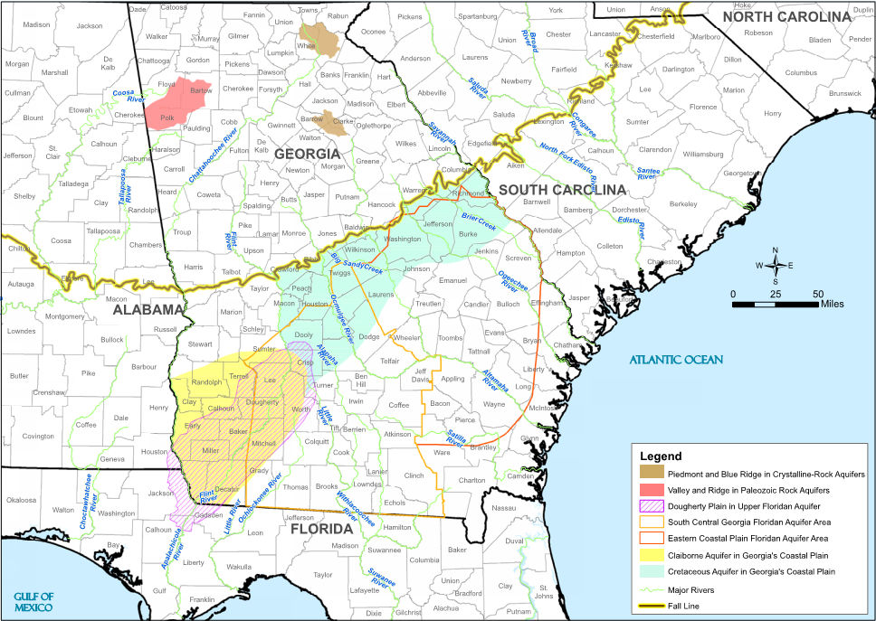
The Groundwater Availability Resource Assessment was undertaken for the first time in 2010 and updated in 2017. The specific prioritized aquifers that were chosen for analysis are shown in the figure below. The results of the initial assessment are included in the 2010 Groundwater Availability Resource Assessment report.
Between 2014 and early 2017, additional groundwater assessments were conducted in response to recommendations made by several Regional Water Planning Councils in the 2011 Regional Water Plans. The updated information is included in the 2017 Groundwater Availability Resource Assessment report, which supplements the estimated sustainable yield ranges prepared in 2010 for specific prioritized aquifers in Georgia.