surface_water_availability.png
An official website of the State of Georgia.
The .gov means it’s official.
Local, state, and federal government websites often end in .gov. State of Georgia government websites and email systems use “georgia.gov” or “ga.gov” at the end of the address. Before sharing sensitive or personal information, make sure you’re on an official state website.
Still not sure?
Call 1-800-GEORGIA to verify that a website is an official website of the State of Georgia.
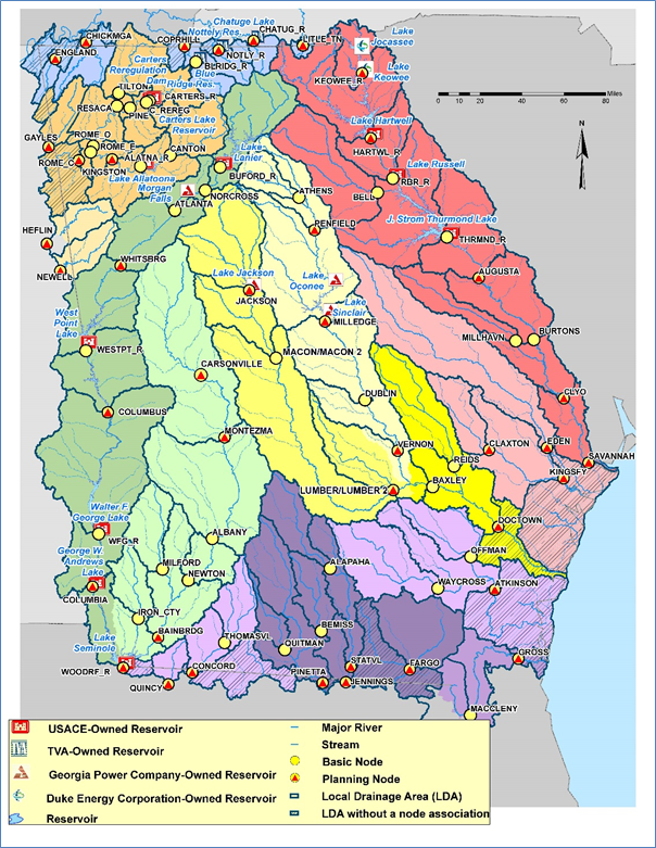
The Surface Water Availability resource assessment evaluated the impact of water consumption on streamflows at certain locations in each river basin (referred to as planning nodes). Consumption is defined as withdrawals from a water body that are not returned to that water body. Streamflows were compared with low flow thresholds selected as an indicator of the potential for water consumption to impact instream uses such as fishing, boating, and aquatic life habitat. For streams where federal requirements for reservoir releases are in place, low flow thresholds have been established through site-specific analysis. In other streams, a low flow threshold from state policy was used.
The Surface Water Availability resource assessment was undertaken for the first time in 2010 and updated in 2017. Updates that were included in the 2017 assessment include: